
Shri Naveen Patnaik
Hon´ble Chief Minister,
Chilika At a Glance
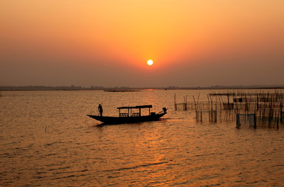
Situated on the east coast of India, and connected to the Bay of Bengal through a narrow sea mouth, Chilika is also a lagoon. And like all coastal lagoons, its waters are rich with life.
It is the largest brackish Water Lagoon with estuarine character that sprawls along the east coast. It is the largest wintering ground for migratory waterfowl found anywhere on the Indian sub-continent. It is one of the hotspot of biodiversity in the country, and some rare, vulnerable and endangered species listed in the IUCN Red List of threatened Animals inhabit in the lagoon for atleast part of their life cycle. A survey of the fauna of Chilika carried out by the Zoological Survey of India in 1985-87 recorded over 800 species in and around the lagoon. This list includes a number of rare, threatened and endangered species, including the Barakudia limbless skink. On account of its rich bio-diversity and ecological significance, Chilika was designated as the 1st "Ramsar Site" of India. The Nalaban Island within the lagoon is notified as a Bird Sanctuary under Wildlife (Protection) Act, the National Wetlands, mangroves and coral reefs Committee of Ministry of Environment & Forests, Government of India, have also identified the lagoon as a priority site for conservation and management. The Lagoon is a highly productive ecosystem, with rich fishery resources. The rich fishing ground sustain the livelihood of more than 0.15 million fisherfolk who live in and around the Lagoon.
The waterspread area of Chilika varies between 1165 to 900 sq.km during the monsoon and summer respectively. A 32 km long, narrow, outer channel connects the main lagoon to the Bay of Bengal, near the village Motto. The mouth connecting the channel to the sea is close to the Northeastern end of the lagoon.
High tides near this inlet mouth drive in salt water through the channel during the dry months, from December to June. With the onset of the rains, the 52 river and rivulets falling into the Chilika are in spate, causing fresh water currents which gradually push the sea water out. Due to littoral drift prevailing along the east coast the inlet mouth constantly changes position.
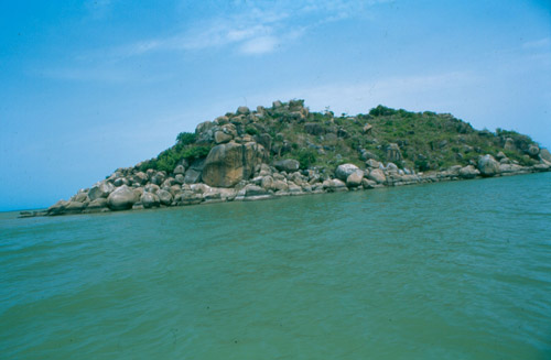
The lagoon itself can be broadly divided into four ecological sectors based on salinity and depth: the southern zone, central zone, northern zone and the outer channel. A number of islands are present in the lagoon with habitation and without the habitation, prominent among which are Krushnaprasad, Nalaban, Kalijai, Somolo, Honeymoon, Breakfast and Birds Island.
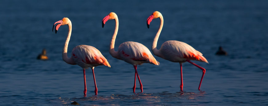
Chilika supports some of the largest congregation of migratory birds in the country, particularly during the winter. Flocks of migratory waterfowl arrive from as far as the Caspian Sea, Lake Baikal, Aral Sea, remote parts of Russia, Kirghiz steppes of Mongolia, Central and South East Asia, Ladakh and the Himalayas, to feed and breed in its fertile waters. In 1989-90 an estimated two million birds visited the Lake.Recently based on the survey by the Forest Department ( 2014) 158 species of birds were listed from the lagoon.
Flora :- Phytoplankton flora-399 sp, algal communities-22 sp, Vascular plants 720 sp. Fauna :- Fishes-267 sp, Protozoa-61 sp, Platyhelminthes-29 sp, Nematodes-37 sp, Polychaetes-31 sp, Mollusca-136 sp,-Crustacea m-28 sp., Decapoda-35 sp., Amphibian & Reptile-37 sp, Birds-225 sp, and Mammals-18 sp.
Location and Topography
Chilika Lagoon lies in the districts of Puri ,Khurda and Ganjam of Odisha State along the eastern coast of India. It is well connected to the Chennai and Kolkata through National Highway No 5, and the Chennai Kolkata rail line passes along the western bankof the Lagoon Balugaon, with Balugaon, Chilika and Rambha being the main stations along the Western shoreline of the lagoon. Chilika lies about 50 km southwest of the city of Puri from where it is connected by road up to Satpara on the eastern bank.
Chilika is a shallow lagoon with estuarine character. It can be divided in to four ecological sectors i.e. the Northern, Cental, Southern and Outer Channel. The major part of the lagoon (the Nothern sector) has a depth of less than 50 cm, while the maximum depth of 3.7m is encountered in the central sector. The link between the lagoon and the outer channel (Muggermukh) was 20cm and was preventing the exchange of water between sea and the lagoon. The pear-shaped lagoon is about 64.5 km long and its width varies from 18 km to 5 km (Das and Samal 1988). The lagoon is connected to sea by a 32 km long, channel with several shoal restricting the flow and head loss . About 1.5 km wide, the channel runs parallel to the Bay of Bengal and is separated from it by a narrow spit whose width very between 100m to several kilometers. In the late 1990s Chilika was regarded as a dying lake. The lake was included in the Montreux Record (threatened list) in 1993 due to change in its ecological character by Ramsar Convention. But in 2000 a new mouth was opened by CDA as per the recommendation of the CWPRS' Pune, based on the rigorous mathematical modelling. Seawater is Chilika's lifeblood. Without a regular inflow, the lake ecosystem would decline. Thanks to ecological restoration by the CDA, it's once again a source of livelihood for thousands - and a refuge for a variety of wildlife. The lake was removed from the Montreux record in 2002 (1st from Asia) by Ramsar convention due to successful restoration and CDA was conferred with prestigious Ramsar Wetland Conservation Award in 2002.
Lagoon Basin
52 number of rivers and rivulets drain into Chilika Lagoon . Siltation due to change in the land use pattern is considered to be one of the most importanr factor for degradation of the Lagoon ecosystem. To address this issue , CDA delineated the microwatersheds. Micowatersheds are considered as the functional ecological unit for sustainable management. It was observed that the degradation of the land is prevalent in the catchment area, resulting in decline in the productivity and accelerating the poverty and unsustainable pressure on the natural resources leading to further depletion the resource and degradation of land. The approach adopted by CDA is treatment of the most degraded catchment in a holistic manner on micro watershed basis in a participatory manner involving the watershed community and to address not only the the land, water, management but also focus on the appropriate management of the natural resources and its wise use.
CDA adopted an innovative participatory micro watershed based approach which is a deviation from the conventional approach of implementing rather than facilitating. Watershed rehabilitation is conceived as a resource-based approach, with an objective of livelihood enhancement. The micro watershed concept aims to establish an enabling environment for the integrated use regulation and sharing of water and land resources of the watershed based ecosystem to accomplish resource conservation, arrest soil erosion thus reduce the silt load in to the lagoon and enhance biomass production. The above preparatory process, facilitates the community to formulate the site specific micro-plan with a major input in form of their indigenous technical knowledge and skills, which is supplemented through learning from various training programmes organized under the aegis of the project, with an objective of empowerment and the capacity building of the community and the community based organisations at the grass root level.